


Since everyone is back in school, we figured you were probably up to your neck in geography homework. We've put together a glossary of map terms, so now you have no excuse for getting lost in the hallway and finding yourself back under those warm blankets. Below are Map Terms - A to C!
Axis - An imaginary line the Earth rotates around. When speaking about maps and globes it's the line that measurements are made from to determine a specific location.
Bar scale - This is that part of the map that looks like a ruler. It's a line that is used to measure distance on a map. The line is divided into units that are equivalent to the scale of the map. It is numbered so you know the distance of each mark from the zero mark on the line.
Base map - A map with all the important information about the Earth's surface - like landforms, drainage, landmark features and political boundaries. Most of them have labels or names. They come in a series and are used as a reference for thematic information. Examples of base maps include topographic and planimetric maps.
Bearing - Also known as direction. Bearings are determained by the direction (usually angular) from one position to another using geographical (land) or celestial (stars) reference lines. If the angle is measured clockwise from the north, then it is called bearing east. If it's measured counter-clockwise it is called bearing west. Bearings can be measured from True North, grid north or magnetic north. Bearings and headings mean the same thing except bearing is a fixed position and heading is the direction that an object moves.
Cardinal Direction - This is one way to give directions. Instead of saying, "Turn left at McDonald's, then go right at the gas station," cardinal directions use north, south, east and west. You would say, "Go west at the McDonald's and north at the gas station."

Cartesian coordinate system - Your teacher gives you a map of Mexico and tells you to find Mexico City. You won't have a problem if you know the Cartesian system. X measures the horizontal distance (across) and Y measures vertical distance (up and down). There are intersecting straight lines (called axes) that are all the same length. You can measure distance, area and direction by following two intersecting axes along a line parallel to the other axis.
Cartography - The
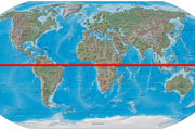
Central meridian - A line running north and south at the center of a map (or other design), which has been divided into squares so the map can be put into other dimensions. All the points along the line have the same longitude.
Compass - This is the instrument to have if you're ever lost. A magnetic needle on a round dial or card tells you where north is. Regardless of where you are, the needle always points north. A different kind of compass is always used for drawing and measuring circles.

Coordinates - A set of numbers on a map used to find the distance from a specific place, also known as the origin. In a Cartesian coordinate system, there's an "x,y" location or an "x,y,z" location (If the system is 3-dimensional). See Cartesian coordinate system.
- To learn about Map Terms C - P click here.
- To learn about Map Terms P - Z click here.
Related Stories: